First look at Common Side Effects
Posted: July 27, 2024 Filed under: America Since 1945, art, comedy, drugs, film, hely, how to live, pictures, plays, screenwriting, story, the world around us, Wonder Trail Leave a commentFor the past couple of years I’ve been working on this animated show I co-created with the great Joe Bennett. Even adjusting for my personal bias, I believe it came together in an amazing way and will be an incredible show. Coming in 2025.
Barbarian Days
Posted: April 25, 2019 Filed under: news, Tahiti, the world around us, travel, world Leave a comment
sometimes reading “the news” I am reminded of this part from Barbarian Days:
In the cemeteries in Tonga, late in the day, there always seemed to be old women tending the graves of their parents – combing the coral-sand mounds into proper coffin-top shape, sweeping away leaves, hand-washing faded wreaths of plastic flowers, rearranging the haunting patterns of tropical peppercorns, orange and green on bleached white sand.
A shiver of secondhand sorrow ran through me. And an ache of something else. It wasn’t exactly homesickness. It felt like I had sailed off the edge of the known world. That was actually fine with me. The world was mapped in so many different ways. For worldly Americans, the whole globe was covered by the foreign bureaus of the better newspapers – the New York Times, the Washington Post, the Wall Street Journal – and, at that time, the big newsweeklies. Every place on earth was part of somebody’s beat. Bryan understood that map before I did, having gone to Yale. But when I’d found an old copy of Newsweek on Captain Brett Hilder’s bridge, and tried to read a George Will column, I’d burst out laughing. His Beltway airs and provincialism were impenetrable. The truth was, we were wandering now through a world that would never be a part of any correspondent’s beat (let alone George Will’s purview). It was full of news, but all of it was oblique, mysterious, important only if you listened and watched and felt its weight.
As the Jamaican cab driver said, the news is a Babylon thing.
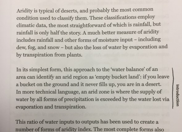
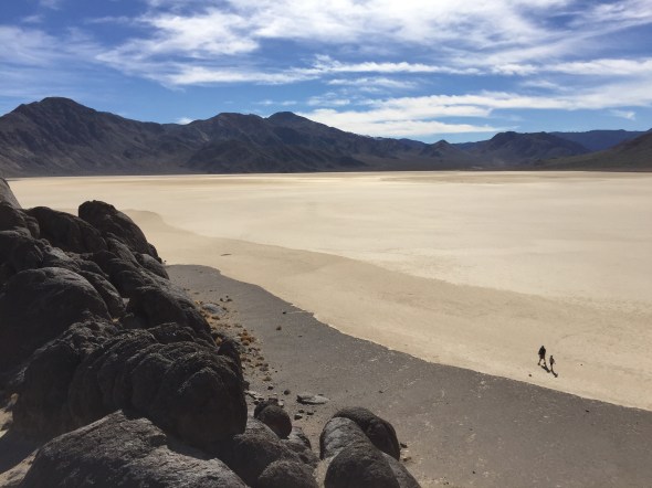
Empty Bucket Land
Posted: December 13, 2017 Filed under: the California Condition, the world around us Leave a comment
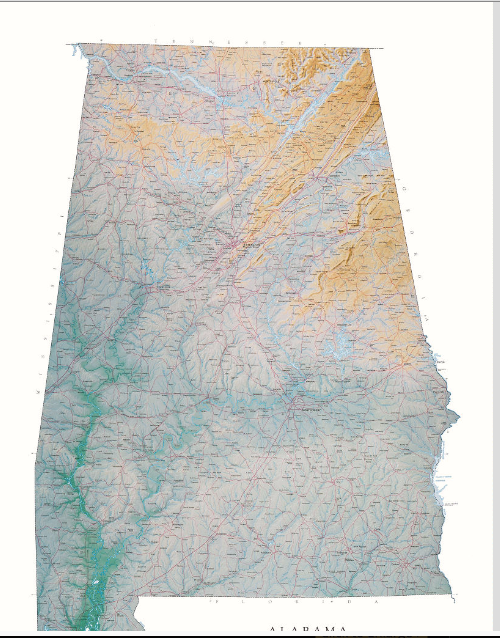
Alabama, Mississippi, slavery, and voting
Posted: March 8, 2017 Filed under: America, politics, the world around us Leave a commentLook at this voting map of Alabama for President, 2016:

And this one of Mississippi: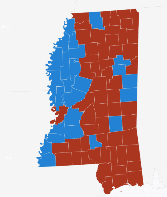
Those are from Politico, 2016 county by county election results.
Compare them to these amazing Raven Maps (I love Raven maps, buy a Raven map) that show elevation:
Look at the Mississippi Delta:
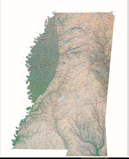
My hypothesis is that the legacy of slavery can be seen in a simple voting map: black people still live in bottomland — cotton country.
You might double check that by looking at racial percentages by county.
No doubt there are factors I haven’t considered.
Compare too to this 1861 Coast Survey slavery map:
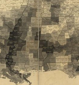
This might demonstrate:
- geography affects history
- historical legacies can last a very long time
- good maps are illuminating
How big are places compared to other places?
Posted: September 9, 2016 Filed under: Australia, maps, New Zealand, the California Condition, the ocean, the world around us Leave a comment
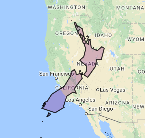
Traveling across the South Island of New Zealand by train, I was trying to work out for myself how big exactly the country is.

It looked big
With the help of OverlapMaps, here’s a comparison of New Zealand to California:
The total land area of New Zealand, says Google, is 103,483 mi²
In US state terms, that makes it just smaller than Colorado, at 104,185 mi².


Colorado has about 1 million more people.
Colorado: 5.356 million (2014)
New Zealand: 4.5 million
Pop wise New Zealand is about the size of Kentucky or Louisiana.

The folks at Brilliant Maps do fantastic work in this field. Here are some of my favorites:
Los Angeles and other cities overlaid on The Netherlands:

Not sure I totally understand what’s going on here.


Map by Chris Stephens, from naturalearthdata.com

Created by: reddit user Tom1099
US in China by population:

How the US population fits into China by reddit user jackblack2323
OR:

Map by reddit user gotrees
The relative size of the 24 largest islands in the world, map by reddit user evening_raga
And The Circle:

Map created by reddit user valeriepieris
Here’s one more for you, from OverlandMaps:

Australia’s population is 23.13 million or so, so it’s about three million people bigger than Florida (20.2 mill) and smaller than Texas (27.46 mill). Whole lotta room down there. About as many people as Illinois and Pennsylvania put together, in a land area (2.97 million square miles) that’s about as big as 51 Illinoises.

one of Australia’s more densely populated areas.
The Boston Globe’s Big Picture Blog
Posted: April 5, 2012 Filed under: photography, pictures, the world around us Leave a comment
Coup In Mali, 2
Posted: April 3, 2012 Filed under: adventures, Mali, science, the world around us, UNESCO Leave a comment
Had a vague idea that I might go to Dogon country in Mali, ever since I read about it in Lonely Planet’s list of the world’s ten best treks. Now seems like an especially bad time to go, better stick to the Haute Route. But still, in my reading, came across this interesting or perhaps stupid discussion of whether the Dogon people have advanced astronomical knowledge. (My verdict? WHAT? Definitely not.)

Come with me!
Posted: March 21, 2012 Filed under: adventures, mountains, the world around us, UNESCO Leave a commentTo Reunion Pitons, Cirques, and Remparts UNESCO World Heritage Site!

Pack a lunch! Or should we stop for cari and bonbon piments?
The Chernobyl Ant
Posted: March 19, 2012 Filed under: adventures, animals, nature, the world around us Leave a comment
A famous flyfishing fly, the Chernobyl ant was designed (it appears, research cursory) by Mark Forslund and Allen Wooley, guides on the Green River below Flaming Gorge, Utah.
That picture is from the website of Elburgon Flies Supply, “a leading fly fishing flies supplier in Africa.”
I would like to play a villain in a Nigerian film.
Posted: February 24, 2012 Filed under: film, the world around us Leave a commentAccording to legend, the first Nollywood movie was made by a small-time electronics trader named Kenneth Nnebue, who, stuck with a large shipment of blank videotapes, decided to unload them by making a movie about a man who sells his soul for wealth. That movie, “Living in Bondage” sold hundreds of thousands of copies and established Nollywood’s archetypal plot elements: martial discord, greed, a conflict between Christianity and juju, as the occult is called in West Africa. From these accidental origins, a cultural phenomenon emerged.
– from this great NY Times article about Nigerian cinema.
